
With the cruise control set to a modest 50 mph, a driver navigates along a straight stretch of west coast highway. This driver would not likely be characterized as “reckless” by most people’s standards, but as an out-of-town motorist he’s unaware that he’s going above the average speed that occurs on this roadway. The posted speed limit of 55 mph provides him with nothing more than a false sense of security. As he increases speed slightly to prepare to pass the vehicle in front, he’s only about one mile away from a location that is a notoriously high risk for accidents, with 100 collisions reported last year, primarily due to the speed at which cars merge from a connecting on-ramp.
At the same time, across the country where the winters are always harsher between the months of November and February, another driver is proceeding down a winding roadway that is generally safe most of the year but is also known to be a place where drivers accelerate more than they legally should. A quick-moving storm front will bring a mix of snow and rain, rendering the scene and driver prone to a crash, unless she’s pulled over by the police before a disaster ensues.
The point? Both drivers should be able to benefit from better outcomes given the depths of data collection that governmental officials have at their disposal and the availability of global positioning system (GPS) technology today. Intelligence, however, does not always equate to dissemination of knowledge among the public. Yet, two recently improved patents for a GPS program designed to be more “insightful” for those traveling America’s highways could soon improve the rates of injuries and death even if the government’s use of big data continues to be subpar.
Data collection conundrums
Traditionally, the potential for an accident or to be pulled over for speeding could be chalked up to happenstance, coincidence, bad luck, careless driving, or a combination of these factors. But in 2022, in a time when the collection of data and analytics are seemingly a part of every facet of life, the potential for a highway accident and/or traffic violation can now be identified on a scientific level. Through the Internet of Things (IoT) and integrated systems, data can be harnessed to a point that predictive analytics could realistically aid any driver in any situation to avoid tragedy and/or negative driving records—if they only knew risks that they were driving directly into.
Big data analysis is a mature technique that has been utilized by the U.S. government and other organizations throughout the country (and worldwide) in a variety of industries for many years to monitor public and community transportation patterns. Yet, it has not been fully implemented in a way that it will assist drivers to commute more safely every day by preventing traffic accidents and citations. By categorizing traffic data into identifiable patterns or risks, roads could be constructed and navigated in more productive ways. Data could be collected and analyzed in real time and, when combined with historical research, effectively predict potential for roadway incidents based on certain specifications. Those potential risks could then be communicated to commuters through GPS user engagement panels featured on smartphones and other digital devices. The more that these data would be applied to any driver’s daily life, the less possibility there would be for accidents and violations to occur.
The reasons for which these types of data and technology have not been paired widespread in this capacity are open for interpretation, speculation, and debate. As easily as it could be assumed that the U.S. government does not want to invest significant dollars into such a program, it could just as easily be assumed that the financial wherewithal is there but a lack of data organization across the country is the main culprit. Regardless, there’s a prevailing sentiment that the public would have trust issues with government officials implementing big data, and potentially sensitive personal information, for this purpose.
Historical traffic backdrop and big data analysis
Any quick online search provides a full representation of just how much traffic mapping and tracking occurs daily throughout the country, constantly. The U.S. government’s involvement in trying to ensure safety among licensed motorists, which as of 2019 totaled nearly 230 million people, can be traced back to the National Traffic and Motor Vehicle Safety Act of 1966, legislation that required automobile manufacturers to institute safety standards to protect people from unreasonable risks related to how automobiles are produced. The Highway Safety Act, also enacted in 1966, took things a step further to include such considerations as highway design and established the National Highway Safety Bureau (today the National Highway Traffic Safety Administration, or NHTSA) to create uniform safety standards. Today, the NHTSA is tasked with enforcing vehicle performance standards and fostering partnerships with state and local governments to reduce motor vehicle deaths, injuries, and economic losses. While more than 600,000 lives are reported to have been saved by the NHTSA’s various efforts, per the most recent statistics, there are approximately 1.35 million people who die in road crashes each year among the reported six million vehicle crashes annually in the United States.
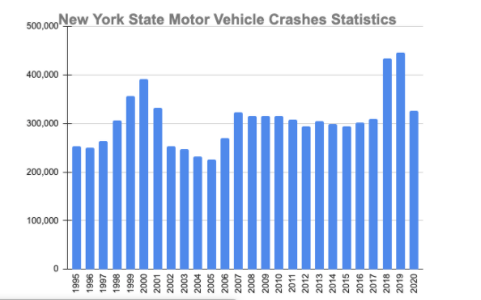
NHTSA’s National Driver Register and Traffic Records Division provides coordinated accessibility of crash, roadway, citation, and other surveillance databases, and is tasked with helping states throughout the country to improve their respective traffic safety data collection, management, and analysis. But there is not a consistent national standard for state and local governments to collect and store their data that enables the data to be consistently shareable or searchable. As such, officials and residents alike depend on the diligence of their respective states to track and utilize data effectively. Some states do a better job than others. New York is an example of a state that does track its data well. The state’s department of motor vehicles (DMV) maintains statistical data about crashes from 1995 through 2014 and crash data from 2015 and beyond is publicly accessible, searchable, and archived by the Traffic Safety Statistical Repository (TSSR). With the available information, a quick summary for crashes between 1995 and 2020 (Figure 1) reveals that vehicle crashes have not been reduced. Importantly, a decline in 2020 must be attributed significantly to the coronavirus (COVID-19) pandemic, which kept people off roadways during times of governmental restrictions. Despite the data repository, crashes increased overall year over year from 2015 through 2019, which demonstrated that virtually nothing was done with the knowledge to reverse the dangerous trend. This lack of commitment in applying big data analysis methods to assist people to have better traffic outcomes should be a concern to anyone who gets behind the wheel today.
How predictive analytics can impact daily driving
If the tracking of individual traffic accidents is the baseline of the requisite big data needed to improve driving safety, there are several ways that government officials could categorize traffic data into data types and user types that correspond to one another. Then, they could utilize predictive analytics to generate specific notifications about potential impending traffic accidents and violations based on the driver’s location and environment. Examples of data sets that could be part of a comprehensive reservoir of information for tracking and mapping, as well as for developing purposeful predictive analytics include:
- Traffic accident- or violation-related data based on vehicle make and model
- Traffic accident/violation -related data based on road type and condition
- Traffic accident/violation -related data based on location
- Traffic accident/violation -related data based on time of day/year
- Traffic accident/violation -related data based on long-term climate and types of variable weather conditions
- Traffic accident/violation-related data based on motorist characteristics and demographics
These modalities are further illustrated through two patent-approved programs for 1) a method and system built for avoidance of accidents and 2) systems and methods for traffic violation avoidance. With these two programs in operation, the thought of offering better protection for more people is possible.
In the former example, a system for mapping and storing traffic violation citations has been designed to alert users of traffic violations. The database offers traffic-related data for commercial and non-commercial vehicles and is synched with identifiers that share details about the location of such events as well as vehicle types and plates. The database also contains historical and real-time traffic violation citations, as well as other traffic-related information that is stored within a central server. A data processing module is utilized to track specific event locations and to analyze the relationship between vehicle information, accelerated speeds, weather, regulations, and reported incidents.
Components of the latter system include a method for mapping traffic accidents, storing historical and real-time accident data, and other accident-related information. A central server stores the data and users are alerted about traffic accidents based on location and the nature of the incidents, such as causes, time, participants, vehicle type, route conditions, weather, and the involvement of any other motorcyclists, bicyclists, and/or pedestrians. The system can also offer the analysis algorithm of a search engine and can analyze historical or real-time traffic accident data that are based on category and geocoded location, route conditions, weather, and vehicle information.
Switching from real-time to predictive
When drivers get into their cars today, they have multiple digital apps to choose from that will provide them with real-time traffic alerts throughout their commutes. Platforms such as Google Maps, Apple Maps, and Waze show these types of data, but they use real-time data and more recent information as opposed to historical information. This begs the question: How valuable is it for a driver to know about an accident that has just happened a few miles away that was very uncharacteristic for that roadway but did not generate a notification to the driver? (It is probably worth acknowledging, however, that these very applications can contribute to today’s motor vehicle accidents when they are accessed in the act of driving, which goes against the apps’ advisory guidelines and highway safety regulations.)
But these newly developed programs have been designed to provide GPS functionality that would offer increased services than today’s typical platforms, including:
- The potential for accidents and violations in specific location or along specific routes based not on real-time data but, rather, historical data
- Consideration of the multiple variable aspects such as weather, road conditions, and vehicle type
- Route suggestions based on less probability of accidents and violations as a means for helping more drivers to reach their destinations safely, with less emphasis on taking the “quickest” route.
Additionally, the functionality will connect the mobile application to a server based on real-time information for drivers, such as weather conditions and historical database information related to the location’s typical speed, violation/accident data, and regulations/traffic laws for purposes of comprehensive analysis that will be delivered to users with precise, short messages received prior to a commute. Without such research, there are no patterns of knowledge as to why, exactly, certain incidences occurred at certain locations under certain circumstances from an historical perspective.
Individual, business and societal benefits
These newly patented systems are also expected to offer benefits that go beyond valuable reference information for drivers and passengers to plan their routes and improve overall societal and industrial functionality. Fewer traffic violations and accidents will bring reduced costs and minimized wastage for transportation field companies; fewer road incidents would also conceivably improve job performance and enthusiasm of professionals working within the transportation sector, as one study from 2018 illustrates.
It’s difficult to envision there being federal guidelines issued for the consistent tracking of such intimate historical data based on individual drivers and their incidences for public consumption. Concerns about privacy abound, and the financial investment to support the technology, not to mention the money that could be lost on collections earned through citations, would be substantial and a deterrent.
It’s possible for governmental officials to collect and disclose data anonymously to appropriate entities, which could result in an expert analysis for distribution and future benefit. As technology continues to be utilized by more people and impacts our lives repeatedly, exposure to such data will create more accurate and useful devices. As more people use technology applications, receive relevant notifications, and impact the roadways by exposing reasons for incidents, the benefits of historical data are key.
In addition to buy-in from governmental agencies, acceptance needs to come from the public if the data and technology are truly going to sync for overall safety. Not everyone will be accepting of such information gathering. Some people will resist due to fears of data abuse, invasion of privacy, and/or security concerns such as data breaches. Resistance to change is typical, however, especially when it comes to technology, even when considering that many of today’s apps that are used by many actually do track the user’s activity and collecting more data than people take the time to realize. But that’s not a good enough reason for the government to ignore the potential benefits. After all, scores of people have been known not to “trust” smartphones and the internet, but time has changed that by and large. The earlier this type of data mining would be accepted overall, the earlier the benefits would be realized. Removing personal, sensitive data for security purposes and establishing a “safe place” for specific analysis tools or methods to be applied would enhance citizens’ trust and quality of life. If the information is used properly, the reduction in accidents and lives saved could be immeasurable.
Future forward
Today’s roadways could be more safely navigated daily, and tomorrow’s roads have the potential to be safer before they’re even paved through the proper utilization of big data analysis that’s available to government officials. Everyday drivers can be put into a better position to prevent potential traffic accidents and lessen their risks of costly citations if given access to the best data that technology has to offer. Data can be collected and analyzed in real time, and when combined with historical research the driver’s daily commute can be contemplated and planned before leaving the house. But who is willing to financially support such a reality, and at what cost? The answer to this question could determine everything.
About the Author:
Shuo Zhang holds a master’s degree in computer science from New York University. He has seven years of experience in the transportation industry, providing IT support for a variety of field transportation projects. He is an Oracle Database 10g Administrator Certified Professional and holds an Inner Examination Qualification Certificate of the ISO900 system of quality certification. Besides providing IT support for different projects, he also has contributed to multiple patents that have been granted by the USPTO. He has also served as a judge for the IT World Awards. For further information, please send email to danielbmeng@gmail.com or visit https://globeeawards.com/shuo-zhang.
Author Disclosure:
Shuo Zhang is on staff at Clean Air car Service & Parking Corp., Queens, NY, and Operr Technologies, Inc., New York, NY, which owns the patents that are referenced in this article. Zhang is credited with helping to build the systems inherent within the two patents, but is not receiving direct compensation as a result of any financial success that the patents might receive.
Tag/s:Artificial IntelligenceCustomer Experience


